Silver Spring is an unincorporated community and census-designated place (CDP) located inside the Capital Beltway in Montgomery County, Maryland, United States. It had a population of 76,716 according to 2013 estimates by the United States Census Bureau, making it the fourth most populous place in Maryland, after Baltimore, Columbia, and Germantown. Silver Spring consists of the following neighborhoods; Downtown Silver Spring, East Silver Spring, Woodside, Woodside Park, North Hills Sligo Park, Long Branch, Montgomery Knolls, Franklin Knolls, Indian Spring Terrace, Indian Spring Village, Clifton Park Village, New Hampshire Estates, and Oakview.
The urbanized, oldest, and southernmost part of Silver Spring is a major business hub that lies at the north apex of Washington, D.C. As of 2004, the Central Business District (CBD) held 7,254,729 square feet (673,986 m2) of office space, 5216 dwelling units and 17.6 acres (71,000 m2) of parkland. The population density of this CBD area of Silver Spring was 15,600 per square mile all within 360 acres (1.5 km2) and approximately 2.5 square miles (6 km2) in the CBD/downtown area. The community has recently undergone a significant renaissance, with the addition of major retail, residential, and office developments.
Silver Spring takes its name from a mica-flecked spring discovered there in 1840 by Francis Preston Blair, who subsequently bought much of the surrounding land. Acorn Park, tucked away in an area of south Silver Spring away from the main downtown area, is believed to be the site of the original spring.

The boundaries of the Silver Spring CDP (in dark orange) as of 2010
As an unincorporated area, Silver Spring’s boundaries are not officially defined. As of the 2010 Census the United States Census Bureau defines Silver Spring as a census-designated place with a total area of 7.92 square miles (20.5 km2), all land; however, it does contain numerous creeks and small lakes. This definition is a 15% reduction from the 9.4 sq. mi. used in previous years. The United States Geological Survey locates the center of Silver Spring at 38°59′26″N 77°1′35″W, notably some distance from the Census Bureau’s datum. By another definition, Silver Spring is located at 39°0′15″N 77°1′8″W (39.004242, -77.019004). The definitions used by the Silver Spring Urban Planning District, the United States Postal Service, the Greater Silver Spring Chamber of Commerce, etc., are all different, each defining it for its own purposes.
Residents of a large swath of South-Eastern Montgomery County have Silver Spring mailing addresses. This area extends roughly from the Washington, D.C., Prince George’s County, Maryland and Howard County, Maryland lines to the west, north and east, and Rock Creek Park and Plyers Mill Road to the west and north-west. This postal code even includes nearby towns; such as Four Corners, Wheaton, Glenmont, Forest Glen, Aspen Hill, Hillandale, White Oak, Colesville, Colesville Park, Cloverly, Calverton, Briggs Chaney, Greencastle, Northwood Park, Sunset Terrace, Fairland, and Kemp Mill. Surprisingly, even a tiny portion of the Langley Park and Adelphi neighborhoods have Silver Spring Zip Codes, though they are in Prince George’s County. These boundaries make Silver Spring larger in area than any city in Maryland except for Baltimore. Some notable landmarks are the world headquarters of Discovery Communications, the AFI Silver Theatre, the NOAA headquarters, the world headquarters of the Seventh-day Adventist Church and the national headquarters of the Ahmadiyya Muslim Community.

Downtown Silver Spring in February 2005, as seen from downtown Bethesda
Parks and recreation

Acorn Park, site of the “silver spring”
Rock Creek Park passes along the west side of Silver Spring, and offers hiking trails, picnic grounds, and bicycling on weekends, when its main road, Beach Drive, is mostly closed to motor vehicles.
Sligo Creek Park follows Sligo Creek through Silver Spring; it offers hiking trails, tennis courts, playgrounds and bicycling. The latter is facilitated on weekends, when parts of Sligo Creek Parkway are closed to automobiles. The bike trails are winding and slower than most in the region. Recently, rocks have been spread along either side of the road, providing a hazardous bike ride, or skating leisure.
Acorn Park in the downtown area of Silver Spring is believed to be the site of the eponymous “silver spring”.
The 14.5-acre (59,000 m2) Jesup Blair Park was recently renovated and features a soccer field, tennis courts, basketball courts, and picnic area.
Brookside Gardens is a 50-acre (20 ha) park within Wheaton Regional Park, in “greater” Silver Spring. It is located on the original site of Stadler Nursery (now in Laytonsville, Maryland).
Northwest Branch Park is a 700-acre (280 ha) park surrounding the Northwest Branch of the Anacostia River. The park includes hiking, equestrian, and cycling trails on the Northwest Branch and Rachel Carson Greenway Trails. This park is part of Silver Spring and extends farther within Montgomery County. Note that the Rachel Carson Greenway Trail is named after Rachel Carson, author of Silent Spring and former resident of Silver Spring.[citation needed]
Demographics
| Historical population |
| Census |
Pop. |
|
%± |
| 1960 |
66,348 |
|
— |
| 1970 |
77,496 |
|
16.8% |
| 1980 |
72,893 |
|
−5.9% |
| 1990 |
76,046 |
|
4.3% |
| 2000 |
76,540 |
|
0.6% |
| 2010 |
71,452 |
|
−6.6% |
source:[8][9]
note: land area of Silver Spring CDP
reduced by 15% for 2010 census |
As of the 2010 census, there were 71,452 people, 28,837 households, and 15,684 families residing in the Silver Spring CDP. The population density was 9,021.7 people per square mile (3,485.5/km²). There were 30,522 housing units at an average density of 3,853.8 per square mile (1,488.9/km²).
The median income for a household in the census area was $71,986, and the median income for a family was $84,136.[11] Males had a median income of $46,407 versus $49,979 for females. The per capita income for the area was $32,181. 15.0% (+/- 4.9%) of the population and 13.3% (+/-4.3%) of families were below the poverty line. 21% (+/- 9.1%) of those under the age of 18 and 23.6% (+/-10.6%) of those 65 and older were living below the poverty line.
History
Nineteenth century
The Blair, Lee, and Jalloh and Barrie families, three politically active families of the time, are irrefutably tied to Silver Spring’s history. In 1840, Francis Preston Blair, who later helped organize the modern American Republican Party, along with his daughter, Elizabeth, discovered a spring flowing with chips of mica (the now-dry spring is still visible at Acorn Park). Two years later, he completed a twenty-room mansion he dubbed Silver Spring on a 250-acre (one-square-kilometer) country homestead situated just outside Washington, D.C. (The house stood until 1954.[13]) By 1854, Blair’s son, Montgomery Blair, who became Postmaster General under Abraham Lincoln and represented Dred Scott before the United States Supreme Court, built the Falkland house in the area. By the end of the decade, Elizabeth Blair married Samuel Phillips Lee, third cousin of future Confederate leader Robert E. Lee, and gave birth to a boy, Francis Preston Blair Lee. The child would eventually become the first popularly elected Senator in United States history.
During the American Civil War, Abraham Lincoln visited the Silver Spring mansion multiple times. During some of the visits he relaxed by playing town ball with Francis P. Blair’s grandchildren.[14] In 1864, Confederate Army General Jubal Early occupied Silver Spring prior to the Battle of Fort Stevens. After the engagement, fleeing Confederate soldiers razed Montgomery Blair’s Falkland residence.[15] By the end of the 19th century, the region began to develop into a town of decent size and importance. The Baltimore & Ohio Railroad‘s Metropolitan Branch opened on April 30, 1873, and ran from Washington, D.C. to Point of Rocks, Maryland, through Silver Spring.[16] The first suburban development appeared in 1887 when Selina Wilson divided part of her farm on current-day Colesville Road (U.S. Route 29) and Brookeville Road into five- and ten-acre (20,000- and 40,000 m²) plots. In 1893, Francis Preston Blair Lee and his wife, Anne Brooke Lee, gave birth to E. Brooke Lee, who is known as the father of modern Silver Spring for his visionary attitude toward developing the region.[17]
Twentieth century
The early 20th century set the pace for downtown Silver Spring’s growth. E. Brooke Lee and his brother, Blair Lee I, founded the Lee Development Company, whose Colesville Road office building remains a downtown fixture. Dale Drive, a winding roadway, was built to provide vehicular access to much of the family’s substantial real estate holdings. Suburban development continued in 1922 when Woodside Development Corporation created Woodside Park, a neighborhood of 1-acre (4,000 m2) plot home sites built on the former Noyes estate in 1923. In 1924, Washington trolley service on Georgia Avenue (present-day Maryland Route 97) across B&O’s Metropolitan Branch was temporarily suspended so that an underpass could be built. The underpass was completed two years later, but trolley service never resumed. It would be rebuilt again in 1948 with additional lanes for automobile traffic, opening the areas to the north for readily accessible suburban development.
Takoma-Silver Spring High School, built in 1924, was the first high school for Silver Spring. The community’s rapid growth led to the need for a larger school. In 1935, when a new high school was built at Wayne Avenue and Sligo Creek Parkway, it was renamed Montgomery Blair High School. (The school remained at that location for over six decades, until 1998, when it was moved to a new, larger facility at the corner of Colesville Road (U.S. Route 29) and University Boulevard (Maryland Route 193). The former high school building became a combined middle school and elementary school, housing Silver Spring International Middle School and Sligo Creek Elementary School.) The Silver Spring Shopping Center (built by developer Albert Small) and the Silver Theatre (designed by noted theater architect John Eberson) were completed in 1938, at the request of developer William Alexander Julian. The Silver Spring Shopping Center was unique because it was one of the nation’s first retail spaces that featured a street-front parking lot. Conventional wisdom held that merchandise should be in windows closest to the street so that people could see it; the shopping center broke those rules (the shopping center was purchased by real estate developer Sam Eig in 1944 who was instrumental in attracting large retailers to the city).
By the 1950s, Silver Spring was the second busiest retail market between Baltimore and Richmond, with the Hecht Company, J.C. Penney, Sears, Roebuck and Company, and a number of other retailers. In 1954, after standing for over a century, the Blair mansion “Silver Spring” was razed and replaced with the Blair Station Post office. In 1960, Wheaton Plaza (later known as Westfield Wheaton), a shopping center several miles north of downtown Silver Spring opened, and captured much of the town’s business. The downtown area soon started a long period of decline.
On December 19, 1961, a two-mile (3.2 km) segment of the Capital Beltway (I-495) was opened to traffic between Georgia Avenue (MD 97) and University Boulevard East (MD 193).[22][23] On Monday, August 17, 1964, the final segment of the 64-mile (103 km) Beltway was opened to traffic,[24] and a ribbon-cutting ceremony was held near the New Hampshire Avenue interchange, with a speech by then-Gov. J. Millard Tawes,[25] who called it a “road of opportunity” for Maryland and the nation.[26]
Washington Metro rail service into Washington, D.C. helped breathe life into the region starting in 1978 with the opening of the Silver Spring station. The Metro Red Line was built following the alignment of the B&O Metropolitan Branch, with the Metro tracks centered between the B&O’s eastbound and westbound mains. The Red Line heads south to downtown DC from Silver Spring, running at grade before descending into Union Station. By the mid-1990s, the Red Line continued north from the downtown Silver Spring core, entering a tunnel just past the Silver Spring station and running underground to three more stations, Forest Glen, Wheaton and Glenmont.
Nevertheless, the downtown decline continued in the 1980s, as the Hecht Company closed in 1987 and opened a new store at Wheaton Plaza. Furthermore, Hecht’s added a covenant forbidding another department store from renting its old spot. City Place, a multi-level mall, was established in the old Hecht Company building in 1992, but it had trouble attracting quality anchor stores and gained a reputation as a budget mall, anchored by Burlington Coat Factory and Marshalls, as well as now-closed anchors AMC Theatres, Gold’s Gym, Steve and Barry’s, and Nordstrom Rack. JC Penney closed its downtown store—downtown’s last remaining department store—in 1989, opening several years later at Wheaton Plaza. In the late 1980s and early 1990s, developers considered a shopping mall and office project called Silver Triangle, with possible anchor stores Nordstrom, Macy’s, and JC Penney, but no final agreement was reached. Shortly thereafter, in the mid-1990s, developers considered building a mega-mall and entertainment complex called the American Dream (similar to the Mall of America) in downtown Silver Spring, but the revitalization plan fell through before any construction began because the developers were unable to secure funding. However, one bright spot for downtown was that the National Oceanographic and Atmospheric Administration (NOAA) consolidated its headquarters in a series of 4 new high-rise office buildings near the Silver Spring Metro station in the late 1980s and early 1990s.
Another notable occurrence in Silver Spring during the 1990s was a 1996 train collision on the Silver Spring section of the Metropolitan line. On February 16 of that year, during the Friday-evening rush hour, a MARC commuter train bound for Washington Union Station collided with the Amtrak Capitol Limited train and erupted in flames on a snow-swept stretch of track in Silver Spring, leaving eleven people dead.
The Maryland State Highway Administration started studies of improvements to the Capital Beltway in 1993,[27] and have continued, off and on, examining a number of alternatives (including HOV lanes and high-occupancy toll lanes) since then.
Twenty-first century
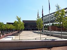
Civic Building and Veterans Plaza
At the beginning of the 21st century, downtown Silver Spring began to see the results of redevelopment. Several city blocks near City Place Mall were completely reconstructed to accommodate a new outdoor shopping plaza called “Downtown Silver Spring.” New shops included national retail chains such as Whole Foods Market, a 20-screen Regal Theatres, Men’s Wearhouse, Ann Taylor Loft, DSW Shoe Warehouse, Office Depot, and the now-closed Pier 1 Imports, as well as many restaurants, including Panera Bread, Red Lobster, Cold Stone Creamery, Fuddruckers, Potbelly Sandwich Works, Nando’s Peri-Peri, and Chick-fil-a. A Borders book store was a popular spot until it closed when the chain went out of business; it was replaced by H&M. In addition to these chains, Downtown Silver Spring is home to a wide variety of family-owned restaurants representing its vast ethnic diversity. As downtown Silver Spring revived, its 160-year history was celebrated in a PBS documentary entitled Silver Spring: Story of an American Suburb, released in 2002. In 2003, Discovery Communications completed the construction of its headquarters and relocated to downtown Silver Spring from nearby Bethesda. The same year also brought the reopening of the Silver Theatre, as AFI Silver, under the auspices of the American Film Institute. Development continues with the opening of new office buildings, condos, stores, and restaurants. In 2015-16, the long-struggling City Place Mall underwent a complete renovation, had its name changed to Ellsworth Place, and brought in new tenants, including TJ Maxx, Ross Dress for Less (a re-opening original tenant), Michaels, Forever 21, and Dave & Buster’s. The restoration of the old B&O Passenger Station was undertaken between 2000 and 2002, as recorded in the documentary film Next Stop: Silver Spring. In 2005 Downtown Silver Spring was awarded the Rudy Bruner Award for Urban Excellence silver medal.
Beginning in 2004, the downtown redevelopment was marketed locally with the “silver sprung” advertising campaign, which declared on buses and in print ads that Silver Spring had “sprung” and was ready for business. In June 2007, The New York Times noted that downtown was “enjoying a renaissance, a result of public involvement and private investment that is turning it into an arts and entertainment center”.
In 2007, the downtown Silver Spring area gained attention when an amateur photographer was prohibited from taking photographs in what appeared to be a public street. The land, leased to the Peterson Cos., a developer, for $1, was technically private property. The citizens argued that the Downtown Silver Spring development, partially built with public money, was still public property. After a protest on July 4, 2007, Peterson relented and allowed photography on their property under limited conditions. Peterson also claimed that it could revoke these rights at any time. The company further stated that other activities permitted in public spaces, such as organizing protests or distributing campaign literature, were still prohibited. In response, Montgomery County Attorney Leon Rodriguez said that the street in question, Ellsworth Drive, “constitutes a public forum” and that the First Amendment‘s protection of free speech applies there. In an eight-page letter, Rodriguez wrote, “Although the courts have not definitively resolved the issue of whether the taking, as opposed to the display, of photographs is a protected expressive act, we think it is likely that a court would consider the taking of the photograph to be part of the continuum of action that leads to the display of the photograph and thus also protected by the First Amendment.” The incident was part of a trend in the United States regarding the blurring of public and private spaces in developments built with both public and private funds.
In 2008, construction of the long-planned Intercounty Connector (ICC), which crosses the upper reaches of Silver Spring, got under way. The highway’s first section opened on February 21, 2011; the entire route was completed by 2012.
In July 2010, the Silver Spring Civic Building and Veterans Plaza opened in downtown Silver Spring.
Culture
American Film Institute Silver Theater
Downtown Silver Spring hosts several entertainment, musical, and ethnic festivals, the most notable of which are the Silverdocs documentary film festival held each June and hosted by Discovery Communications and the American Film Institute, as well as the annual Thanksgiving Day Parade (Saturday before Thanksgiving) for Montgomery County. The Silver Spring Jazz Festival has become the biggest event of the year drawing 20,000 people to the free festival held on the second Saturday in September. Featuring local jazz artists and a battle of high school bands, the Silver Spring Jazz Festival has featured such jazz greats as Wynton Marsalis, Arturo Sandoval, Sérgio Mendes, Aaron Neville and such bands as the Mingus Big Band and the Fred Wesley Group.
The Fillmore is a live entertainment and music venue with a capacity of 2,000 people. It opened in 2011 in the former JC Penney building on Colesville Road. The venue joins the American Film Institute and Discovery Communications as cornerstones of the downtown Silver Spring’s arts and entertainment district. It has featured performances by artists Prince Royce, Minus the Bear, Tyga and many other hip hop acts. In August 2012 R&B singer Reesa Renee launched her album Reelease at the Fillmore.
Downtown Silver Spring is also home to the Cultural Arts Center, Montgomery College. The Cultural Arts Center offers a varied set of cultural performances, lectures, films, and conferences. It is a resource for improving cultural literacy, encouraging cross-cultural understanding, and to build bridges between the arts, cultural studies, and all disciplines concerned with the expression of culture.
Dining in Silver Spring is also extremely varied, including American, African, Burmese, Ethiopian, Moroccan, Italian, Mexican, Salvadoran, Jamaican, Vietnamese, Lebanese, Thai, Chinese, Indian, Greek, and fusion restaurants, as well as many national and regional chains.
Silver Spring has many churches, synagogues, temples, and other religious institutions, including the World Headquarters of the Seventh-day Adventist Church. Silver Spring serves as the primary urban area in Montgomery County and its revitalization has ushered in an eclectic mix of people and ideas, evident in the fact that the flagship high school (Montgomery Blair High School) has no majority group with each major racial and ethnic group claiming a significant percentage.
Silver Spring hosts the American Film Institute Silver Theatre and Culture Center, on Colesville Road. The theatre showcases American and foreign films. Discovery Communications, a cable TV and satellite programming company, has its headquarters in downtown, as well. Gandhi Brigade, a youth development media project, began in Silver Spring out of the Long Branch neighborhood. Docs in Progress, a non-profit media arts center devoted to the promotion of documentary filmmaking is located at the “Documentary House” in downtown Silver Spring. Silver Spring Stage, an all-volunteer community theater, performs in Woodmoor, approximately 3 miles (4.8 km) north up Colesville Road from the downtown area. Downtown Silver Spring is also home to the National Oceanic and Atmospheric Administration (NOAA), an agency of the United States Department of Commerce that includes the National Weather Service; the American Nurses Association; and numerous real estate development, biotechnology, and media and communications companies.
Transportation

Welcome sign on Georgia Avenue
The major roads in Silver Spring are mostly 3- to 5-lane highways. The Capital Beltway can be accessed from Georgia Avenue (MD 97), Colesville Road (US 29), and New Hampshire Avenue (MD 650).
The long-planned Intercounty Connector (ICC) (MD-200) toll road opened in three segments between February 2011 and November 2014. ICC interchanges in the Silver Spring area include Georgia Avenue, Layhill Road (MD-182), New Hampshire Avenue, Columbia Pike (US-29) and Briggs Chaney Road.
Silver Spring is serviced by the Brunswick Line of the MARC Train, Metrorail Red Line, Metrobus, Ride On, and the free VanGo. The bus terminal at the Silver Spring Rail Station is the busiest in the entire Washington Metro Area, and provides connections between several transit services, including those mentioned above. This transit facility serves nearly 60,000 passengers daily.
Construction commenced in October 2008 on the new $91 million Paul S. Sarbanes Transit Center which will further expand the station to facilitate the growing demand for public transportation, due to the increase in population in the Silver Spring area. The new center is a multilevel, multimodal facility which incorporates Metrobus, Ride On, Metrorail, MARC train, intercity Greyhound bus, and local taxi services under one roof. The project was completed over four years behind schedule and $50M over budget. The center opened on September 20, 2015.
The Purple Line light rail, being studied by the Maryland Transit Administration (MTA) is planned to service this station, connecting Silver Spring with Bethesda to the west and then running east to the University of Maryland-College Park and then southeast to the New Carrollton Metro station. Construction was planned to begin in 2015, although as of January 2015 the project had not been fully approved.
In addition to the Silver Spring station, the Washington Metrorail’s Forest Glen station is also located in Silver Spring and the MARC train also stops at the nearby Kensington station.


.jpg)

